Severe Typhoon Vicente slammed Hong Kong on 23 and 24 July 2012, with hurricane force winds blasting places including Cheung Chau.
It was a surprising storm, as even a couple of days earlier it was a large but rather shapeless low pressure system, which formed over the Philippines, then moved over the South China Sea. There was little attention from storm “fans” – even as it intensified into a tropical storm on 22 July. [See, for instance, the Hong Kong Weather Underground forum thread on Vicente – not a lot of posts until around midday on 23 July, then a flurry of activity.]

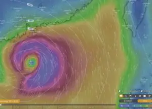
Yet after almost halting for a while, as if to make its mind up, on 23 July Vicente began rapidly intensifying, and headed towards Hong Kong. Though it belatedly made a turn towards the northwest, sparing Hong Kong a direct hit, Typhoon Vicente reached severe typhoon strength according to the Hong Kong Observatory, while the Joint Typhoon Warning Center judged it equivalent to a Category 4 hurricane [on 1-5 scale].
With winds close to the eyewall blasting Hong Kong, and potential for it edging even nearer, the Number 10 storm signal was issued for the first time since Typhoon York in 1999. At Cheung Chau, mean 1-minute winds peaked at 141km/hr – similar to peak wind speeds [around 144km/hr] recorded during Typhoon York, which were the highest since 167km/hr (90-knot) 1-min winds were recorded during Typhoon Ellen in 1983.
Happily, there were no deaths reported during the storm as it passed Hong Kong. Many trees were blown down – surely far more than the 1000 cited in official reports; and even on 26 July there were some severe deluges in the wake of Vicente, particularly over Sai Kung.
According to a report in the South China Morning Post:
[quote]Typhoon Vicente took most people by surprise with its hurricane-force winds – not least atmospheric scientists puzzled by how it intensified in such a short time and distance.
“The typhoon’s action was beyond the expectation of many scientists watching it,” said Professor Johnny Chan Chung-leung, dean of the School of Energy and Environment at City University.
“Even the United States, Japan and China didn’t get it right this time. And everyone is discussing it now.”[/quote]
The discussions include an article on NASA website, which includes:
[quote]Rapid intensification of tropical cyclones is still somewhat of a mystery to forecasters, but one marker that NASA scientists confirmed is when “hot towers” appear within a tropical cyclone as they did in Typhoon Vicente before it exploded in strength on July 23. Vicente made landfall in southern China on July 23.
NASA’s Tropical Rainfall Measuring Mission (TRMM) satellite spotted hot towers in Typhoon Vicente, and it rapidly intensified again within six hours on July 23. By the afternoon (Eastern Daylight time) Vicente’s winds spun up to 120 knots (138 mph/222 kmh). At that time, Vicente was located about 75 nautical miles (86.3 miles/138.9 km) south of Hong Kong and was headed northwest at 8 knots (9 mph/~14 kmh).
A “hot tower” is a tall cumulonimbus cloud that reaches at least to the top of the troposphere, the lowest layer of the atmosphere. It extends approximately nine miles (14.5 km) high in the tropics. The hot towers in Vicente were over 9.3 miles (15 km) high. These towers are called “hot” because they rise to such altitude due to the large amount of latent heat. Water vapor releases this latent heat as it condenses into liquid. NASA research shows that a tropical cyclone with a hot tower in its eyewall was twice as likely to intensify within six or more hours, than a cyclone that lacked a hot tower. Not only did Vicente intensify, but it was almost explosive intensification where sustained winds went from 70 knots (80.5 mph/129.6 kmh) to 120 knots (138 mph/222 kmh) in six hours.[/quote]
NASA’s Sighting of Hot Towers Indicated Typhoon Vicente’s Rapid Intensification
Here’s video I shot as the storm approached and passed over Cheung Chau:
[video:http://www.youtube.com/watch?v=BtNiIyBmlTg]
And a few photos:


Weather including tropical cyclones
Rare November Tropical Cyclones Including Typhoons in Hong Kong
As I write on 13 November 2024, Tropical Cyclone Toraji is set to pass over Hong…
Typhoons and Rainstorms Past Help Hong Kong Forecasts Today
Wetter, Wilder Weather Events Loom with Warming World You may find yourself on a Hong Kong…
“Typhoon to Hong Kong Soon” Makes Great Clickbait
While Hong Kong is sometimes hit by typhoons, predicting them in advance is tricky. Yet this…
Lightning-packed Supercell over Cheung Chau, Hong Kong
Yesterday evening (30 April 2024), weather monitoring imagery showed an intense rainstorm/thunderstorm area – a “supercell”…
Tropical Cyclone Ma-on Headed for Hong Kong
25 August 2022 (evening) update: Ma-on took a track somewhat south and west of earlier forecasts;…
Severe Typhoon Mangkhut highlights perils of massive reclamation by Lantau
Typhoon Mangkhut helped show “storm surge” is a threat to modern cities, not just something for…
Typhoon Jebi a Warning for East Lantau Metropolis aka Lantau Tomorrow Vision
To anyone concerned about plans for Lantau Tomorrow Vision, the clobbering of Kansai by T Jebi…
Mad Lantau Metropolis Plans Should be Scuppered by Storm Surge Threat
A consideration of science suggests the reclamation plans, including for East Lantau Metropolis are foolhardy, even…
As Hong Kong Sizzles the World Keeps Warming
While climate change may have long seemed an issue for hardcore, tree-hugging environmentalists, concerns are spreading.
Typhoon Haiyan Lessons for Hong Kong
Typhoon Haiyan was among the strongest storms on record, and devastated a swathe of the Philippines.…
Forecasters Benefit from Flights into Typhoons
As well as computer models and weather station info, the Hong Kong Observatory is uses flights…
Hong Kong weather outlook warmer wetter wilder
With global warming only just getting started, according to scientists, it’s time for Hong Kong to…
Severe Tropical Storm Pabuk
Severe Tropical Storm Pabuk looked set to have passed Hong Kong, barely causing an impact other…
HK Number 8 Signal
Hong Kong's Number 8 tropical cyclone warning can be controversial.
Hong Kong Typhoons including Calamitous Storm Surges
Typhoons have sometimes caused massive damage and loss of life in Hong Kong. Just months after…
Hong Kong tropical cyclones
Hong Kong can be impacted by tropical cyclones including and typhoons. Happily, typhoons are scarce near…


